
Lancashire highways bosses have apologised after mistakenly publishing plans for a new one-way system that showed traffic would be heading in the opposite direction to the one intended.
The error came to light after the Local Democracy Reporting Service (LDRS) highlighted on Tuesday that a street in St. Annes was set to be revamped as part of a scheme to better connect the seafront to the town centre.
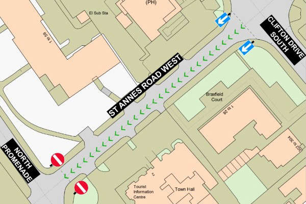
Lancashire County Council had last week launched a public consultation into a proposal to restrict the traffic flow on St. Annes Road West – between North Promenade and Clifton Drive North – enabling one of its footpaths to be widened, in order to make the road more appealing to pedestrians.
The authority issued a map setting out the new arrangements, which showed vehicles would be permitted to travel only from the prom towards the town centre along that stretch of the route.
However, Fylde Council – whose Pier Link project prompted the proposed change – said after the LDRS published details of the scheme that the plan was actually for the one-way system to operate in the reverse direction.
The district authority supplied a different map showing traffic would be allowed only to travel from the main shopping area towards the promenade.
Both maps bore the Lancashire County Council logo – and, when questioned by the LDRS, the highways authority acknowledged that an incorrect version had been published on its website.
The blunder means County Hall has been seeking the views of the public for almost a week about a redesign that was never intended to be introduced in the way it had been presented.
The mix-up was even repeated in written documentation setting out the proposal and forming the basis of the draft traffic regulation order which – in its fully approved form – would have given legal effect to the new rules.
Reference was made to the proposed introduction of one-way traffic on St Annes Road West running from “south west to north east”. That description reflects the direction shown on the erroneous map.
It raises the question as to whether there was a risk that the signage and road markings could ultimately have been implemented the wrong way round – at odds with the designed scheme – if the mistake had not come to light before work began.
Lancashire County Council was unable to answer that question on Wednesday evening, but a spokesperson told the LDRS: “We are aware of an error on a map published as part of the consultation for a proposed traffic regulation order in Fylde.
“The county council manages a large volume of these orders and, unfortunately, on this occasion, an administrative mistake has occurred. We are now taking steps to rectify this and republish.
“We apologise for any confusion this may have caused.”
In a so-called ‘two-tier’ council area like Lancashire, district authorities such as Fylde have to work together with the county council – which is responsible for the roads – on any regeneration projects that involve changes to the highway.
The Pier Link scheme forms part of the second phase of Fylde Council’s broader St. Annes Masterplan, which has already seen the transformation of the town’s public square.
 Major new developments for block including Slug & Lettuce
 Resort school submits fresh plans for new classroom building
 Update over Red Arrows appearance at Blackpool Air Show
 Key work ongoing on Stanley Park’s Grade II-listed Cocker Clock Tower
 Former Frankie and Benny’s restaurant site could be set for revival
 Lorries shown struggling to negotiate junction on new £18.5m road